Geolocate

Pooler topographic map

Click on the map to display elevation.

About this map

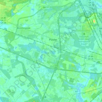
Name: Pooler topographic map, elevation, terrain.

Location: Pooler, Chatham County, Georgia, 31322, United States (32.02745 -81.31156 32.17211 -81.19529)

Average elevation: 7 m

Minimum elevation: -4 m

Maximum elevation: 35 m

Other topographic maps

Click on a map to view its topography, its elevation and its terrain.

Rio Vista

United States > Georgia > Chatham County

Average elevation: 3 m

Oakdale

United States > Georgia > Chatham County > Savannah

Average elevation: 10 m

Welwood

United States > Georgia > Chatham County > Savannah

Average elevation: 7 m

Gear up for your next adventure:

🔦LED Headtorch - Bright and durable light for night activities
Lightweight Backpacking Tent - Compact tent for efficient hiking trips
🪑Insulated Seat Pad - Protect your seat from cold rocks and wet logs
🧥Thermal Layer - Insulating layer for cold outdoor conditions
Camping Tent - Weather-resistant tents suitable for 2 to 6 people

As an Amazon Associate, this site earns from qualifying purchases at no extra cost to you.