
Thank you for supporting this site ❤️
Make a donation
Make a donation
Gear up for your next adventure:
As an Amazon Associate, this site earns from qualifying purchases at no extra cost to you.
Koppel topographic map
Click on the map to display elevation.
Thank you for supporting this site ❤️
Make a donation
Make a donation
Gear up for your next adventure:
As an Amazon Associate, this site earns from qualifying purchases at no extra cost to you.
About this map
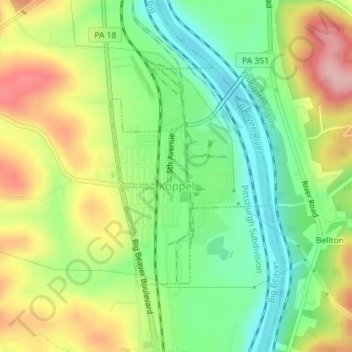
Name: Koppel topographic map, elevation, terrain.
Location: Koppel, Beaver County, Pennsylvania, 16136, United States (40.82662 -80.32897 40.84330 -80.31297)
Average elevation: 287 m
Minimum elevation: 219 m
Maximum elevation: 377 m
Thank you for supporting this site ❤️
Make a donation
Make a donation
Gear up for your next adventure:
As an Amazon Associate, this site earns from qualifying purchases at no extra cost to you.
Other topographic maps
Click on a map to view its topography, its elevation and its terrain.
Big Knob
United States > Pennsylvania > Beaver County > New Sewickley Township
Average elevation: 345 m