
Perimetro Urbano Pereira topographic map
Interactive map
Click on the map to display elevation.
About this map
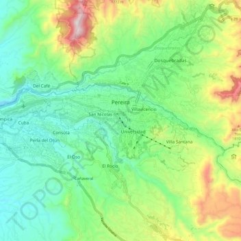
Name: Perimetro Urbano Pereira topographic map, elevation, terrain.
Average elevation: 1,486 m
Minimum elevation: 1,202 m
Maximum elevation: 2,104 m
Pereira is located on the central mountain range, on the Otún river valley, and part of the Cauca river valley. Pereira, like many Colombian cities, has high-elevation areas with difficult access or flat or steep parts. The streets are laid out according to the elevation of the respective zones.
Other topographic maps
Click on a map to view its topography, its elevation and its terrain.
Las Gaviotas
Colombia > Risaralda > Perimetro Urbano Pereira
Las Gaviotas, Bostón, Perimetro Urbano Pereira, Pereira, AMCO, Area Metropolitana Centro Occidente, Risaralda, RAP Eje Cafetero, Colombia
Average elevation: 1,399 m
El Calvario
Colombia > Risaralda > Pereira
El Calvario, Pereira, Risaralda, 66002, Colombia
Average elevation: 1,493 m