Geolocate

Saltville topographic map

Click on the map to display elevation.

About this map

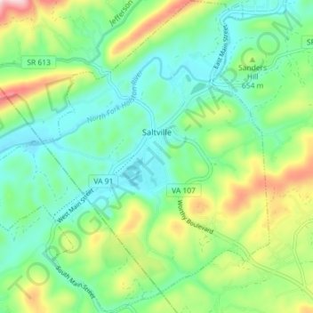
Name: Saltville topographic map, elevation, terrain.

Location: Saltville, Smyth County, Virginia, United States (36.84830 -81.80096 36.90559 -81.73622)

Average elevation: 617 m

Minimum elevation: 507 m

Maximum elevation: 870 m

Gear up for your next adventure:

🧊Portable Cooler - Keep food and drinks cold during outdoor adventures
🥾Hiking Shoes - Durable and comfortable shoes for trail hiking
🧦Outdoor Socks - Durable socks designed for hiking and outdoor sports
🦶Anti-Blister Balm - Prevents friction and hotspots during long ascents
🛶Kayak Dry Bag - Waterproof storage for kayaking adventures

As an Amazon Associate, this site earns from qualifying purchases at no extra cost to you.