
Make a donation
Gear up for your next adventure:
As an Amazon Associate, this site earns from qualifying purchases at no extra cost to you.
Mount Kalatungan topographic map
Click on the map to display elevation.
Make a donation
Gear up for your next adventure:
As an Amazon Associate, this site earns from qualifying purchases at no extra cost to you.
Mount Kalatungan
Mount Kalatungan is the fifth highest mountain in the country with an elevation of 2,880 m (9,450 ft) asl. It is one of the several high elevation peaks in the Kalatungan Mountain Range in Bukidnon on the island of Mindanao, the second largest island in the Philippines.
Make a donation
Gear up for your next adventure:
As an Amazon Associate, this site earns from qualifying purchases at no extra cost to you.
About this map
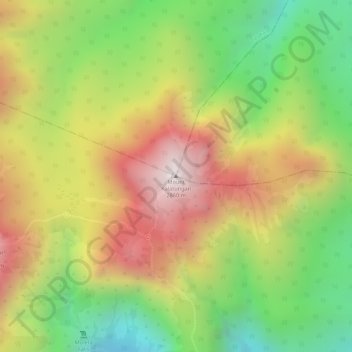
Name: Mount Kalatungan topographic map, elevation, terrain.
Average elevation: 2,481 m
Minimum elevation: 2,079 m
Maximum elevation: 2,864 m
Make a donation
Gear up for your next adventure:
As an Amazon Associate, this site earns from qualifying purchases at no extra cost to you.
Other topographic maps
Click on a map to view its topography, its elevation and its terrain.