Geolocate

Puente Genil topographic map

Click on the map to display elevation.

About this map

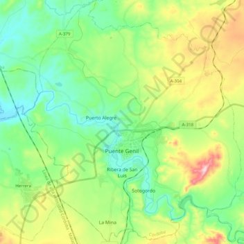
Name: Puente Genil topographic map, elevation, terrain.

Location: Puente Genil, Córdoba, Andalusia, 14500, Spain (37.32850 -4.84981 37.48265 -4.67676)

Average elevation: 257 m

Minimum elevation: 143 m

Maximum elevation: 501 m

Other topographic maps

Click on a map to view its topography, its elevation and its terrain.

Cerro de la Muerte

Spain > Andalusia > La Granjuela

Average elevation: 576 m

Jorox

Spain > Andalusia > Sierra de las Nieves > Alozaina

Average elevation: 566 m

Santiago de la Espada

Spain > Andalusia > Santiago-Pontones

Average elevation: 1,383 m

Gear up for your next adventure:

🌡️Emergency Mylar Blankets - Compact thermal protection for unexpected nights outdoors
🧥Insulated Jacket - Keep warm in cold outdoor conditions
🏕️Camping Hammock - Integrated protection for sleeping between trees
🧴First Aid Kit - Essential first aid supplies for outdoor emergencies
🚲Bike Repair Kit - Essential tools for on-trail mechanical issues

As an Amazon Associate, this site earns from qualifying purchases at no extra cost to you.