Geolocate

Lousame topographic map

Click on the map to display elevation.

About this map

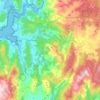
Name: Lousame topographic map, elevation, terrain.

Location: Lousame, Noia, A Coruña, Galicia, Spain (42.71246 -8.92870 42.83426 -8.76550)

Average elevation: 256 m

Minimum elevation: -5 m

Maximum elevation: 666 m

Other topographic maps

Click on a map to view its topography, its elevation and its terrain.

O Castro

Spain > Galicia > Noia > O Porto do Son

Average elevation: 80 m

Froxán

Spain > Galicia > Noia

Average elevation: 333 m

O Lapido

Spain > Galicia > Noia > Porto do Son

Average elevation: 65 m

Gear up for your next adventure:

🥾Light Hiking Boots - Lightweight and comfortable boots for day hikes
🥾Lightweight Hiking Boots - Boots for comfort and mobility on long hikes
💡Solar Camping Lamp - Eco-friendly lighting for campsites
📷Outdoor Action Camera - Capture high-elevation views and rugged adventures
🥾Trail Running Boots - Durable shoes designed for trail running

As an Amazon Associate, this site earns from qualifying purchases at no extra cost to you.