
Make a donation
Gear up for your next adventure:
As an Amazon Associate, this site earns from qualifying purchases at no extra cost to you.
Sanlúcar de Barrameda topographic map
Click on the map to display elevation.
Make a donation
Gear up for your next adventure:
As an Amazon Associate, this site earns from qualifying purchases at no extra cost to you.
Sanlúcar de Barrameda
Sanlúcar de Barrameda borders the municipalities of Trebujena, Jerez de la Frontera, Rota, Puerto de Santa María, and Chipiona. Its topography is shown in the MTN50 sheet (scale 1:50,000) No. 1047 of the National Topographic Map.
Make a donation
Gear up for your next adventure:
As an Amazon Associate, this site earns from qualifying purchases at no extra cost to you.
About this map
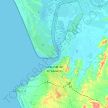
Name: Sanlúcar de Barrameda topographic map, elevation, terrain.
Average elevation: 11 m
Minimum elevation: -3 m
Maximum elevation: 95 m
Make a donation
Gear up for your next adventure:
As an Amazon Associate, this site earns from qualifying purchases at no extra cost to you.
Other topographic maps
Click on a map to view its topography, its elevation and its terrain.