
Thank you for supporting this site ❤️
Make a donation
Make a donation
Gear up for your next adventure:
As an Amazon Associate, this site earns from qualifying purchases at no extra cost to you.
Abbottabad topographic map
Click on the map to display elevation.
Thank you for supporting this site ❤️
Make a donation
Make a donation
Gear up for your next adventure:
As an Amazon Associate, this site earns from qualifying purchases at no extra cost to you.
About this map
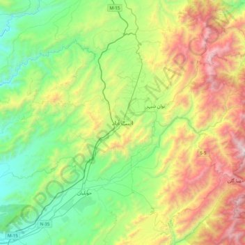
Name: Abbottabad topographic map, elevation, terrain.
Location: Abbottabad, Khyber Pakhtunkhwa, 22010, Pakistan (33.98366 73.05391 34.30366 73.37391)
Average elevation: 1,365 m
Minimum elevation: 570 m
Maximum elevation: 2,939 m
Thank you for supporting this site ❤️
Make a donation
Make a donation
Gear up for your next adventure:
As an Amazon Associate, this site earns from qualifying purchases at no extra cost to you.