Geolocate

Mondavio topographic map

Click on the map to display elevation.

About this map
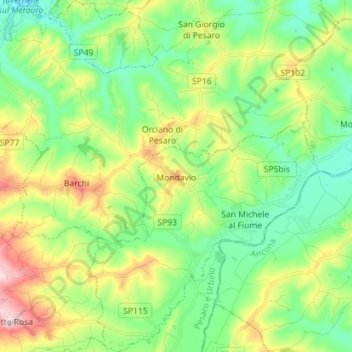
Name: Mondavio topographic map, elevation, terrain.

Location: Mondavio, Pesaro e Urbino, Italy (43.62311 12.91965 43.72581 13.02635)

Average elevation: 167 m

Minimum elevation: 47 m

Maximum elevation: 413 m

Other topographic maps

Click on a map to view its topography, its elevation and its terrain.

Casteldimezzo

Italy > Pesaro e Urbino > Pesaro

Average elevation: 47 m

Gadana

Italy > Pesaro e Urbino > Urbino

Average elevation: 328 m

Palazzo Mucci

Italy > Pesaro e Urbino > Borgo Pace

Average elevation: 710 m

Castello dei Pecorari

Italy > Pesaro e Urbino > Piobbico > Fratta

Average elevation: 508 m

Gear up for your next adventure:

🧥Thermal Fleece Jacket - Versatile insulation for changing mountain temperatures
🌡️Emergency Mylar Blankets - Compact thermal protection for unexpected nights outdoors
🧼Travel Hand Sanitizer - Keep hands clean when water is scarce
🛶Kayak Accessories - Essential gear for safe and fun kayaking adventures
🧶550 Survival Paracord - Versatile utility cord for emergency repairs and rigging

As an Amazon Associate, this site earns from qualifying purchases at no extra cost to you.