
Make a donation
Gear up for your next adventure:
As an Amazon Associate, this site earns from qualifying purchases at no extra cost to you.
Steinenbrück topographic map
Click on the map to display elevation.
Make a donation
Gear up for your next adventure:
As an Amazon Associate, this site earns from qualifying purchases at no extra cost to you.
Steinenbrück
Ortsteile der Kernstadt: Aulhof | Bernsau | Bettenachen | Böke | Brambach | Broich | Brücke | Burg | Burghof | Burgholz | Cyriax | Diepenbroich | Eichen | Eulenthal | Ferrenberg | Griesenbalken | Großbernsau | Gut Eichthal | Gut Ennenbach | Halfensbüchel | Halzemich | Hammermühle | Hasenberg | Höderath | Hufe | Hufenstuhl | Kleinbalken | Kombach | Kotten | Kotterberg | Kram | Kreutzhäuschen | Leyenhaus | Lölsberg | Meegen | Meesbalken | Probstbalken | Rappenhohn | Rittberg | Rottfeld | Schiefenthal | Spich | Voßwinkel | Warth | Wasser | Weberhöhe | Wolfshütte | Wüsterhöhe | Wustsiefen
Make a donation
Gear up for your next adventure:
As an Amazon Associate, this site earns from qualifying purchases at no extra cost to you.
About this map
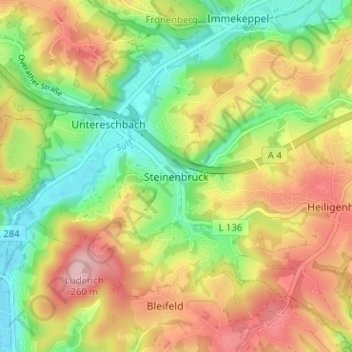
Name: Steinenbrück topographic map, elevation, terrain.
Average elevation: 166 m
Minimum elevation: 84 m
Maximum elevation: 258 m
Make a donation
Gear up for your next adventure:
As an Amazon Associate, this site earns from qualifying purchases at no extra cost to you.