
Make a donation
Gear up for your next adventure:
As an Amazon Associate, this site earns from qualifying purchases at no extra cost to you.
Farmington topographic map
Click on the map to display elevation.
Make a donation
Gear up for your next adventure:
As an Amazon Associate, this site earns from qualifying purchases at no extra cost to you.
Farmington
Farmington has a semi-arid climate. Despite its altitude of 5,473 feet (1,668 m), the city can experience hot summers and cold winters with low precipitation throughout the year. The average annual snowfall is 12.3 inches (31 cm).
Make a donation
Gear up for your next adventure:
As an Amazon Associate, this site earns from qualifying purchases at no extra cost to you.
About this map
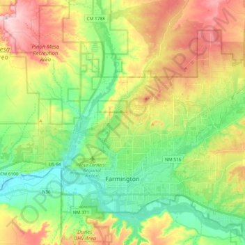
Name: Farmington topographic map, elevation, terrain.
Location: Farmington, San Juan County, New Mexico, United States (36.70670 -108.28410 36.82061 -108.09624)
Average elevation: 1,698 m
Minimum elevation: 1,578 m
Maximum elevation: 1,883 m
Make a donation
Gear up for your next adventure:
As an Amazon Associate, this site earns from qualifying purchases at no extra cost to you.