
Thank you for supporting this site ❤️
Make a donation
Make a donation
Gear up for your next adventure:
As an Amazon Associate, this site earns from qualifying purchases at no extra cost to you.
Donelo topographic map
Click on the map to display elevation.
Thank you for supporting this site ❤️
Make a donation
Make a donation
Gear up for your next adventure:
As an Amazon Associate, this site earns from qualifying purchases at no extra cost to you.
About this map
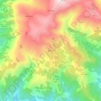
Name: Donelo topographic map, elevation, terrain.
Location: Donelo, Covas do Douro, Sabrosa, Vila Real, 5085-205, Portugal (41.16327 -7.62782 41.20327 -7.58782)
Average elevation: 473 m
Minimum elevation: 97 m
Maximum elevation: 839 m
Thank you for supporting this site ❤️
Make a donation
Make a donation
Gear up for your next adventure:
As an Amazon Associate, this site earns from qualifying purchases at no extra cost to you.