Geolocate

Lynx topographic map

Click on the map to display elevation.

About this map

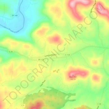
Name: Lynx topographic map, elevation, terrain.

Location: Lynx, Adams County, Ohio, 45650, United States (38.75313 -83.43297 38.79313 -83.39297)

Average elevation: 244 m

Minimum elevation: 155 m

Maximum elevation: 344 m

Gear up for your next adventure:

💧Filtered Water Bottle - Safe drinking water on the go
💧Reusable Water Bottle - Durable water bottles for hydration on trails
🔭Compact Monocular - One-handed bird watching and trail spotting
💧Collapsible Water Bottle - Space-saving water bottle for outdoor activities
Bushcraft Tarp - Versatile emergency shelter or gear protection

As an Amazon Associate, this site earns from qualifying purchases at no extra cost to you.