
Make a donation
Gear up for your next adventure:
As an Amazon Associate, this site earns from qualifying purchases at no extra cost to you.
Bödefeld topographic map
Click on the map to display elevation.
Make a donation
Gear up for your next adventure:
As an Amazon Associate, this site earns from qualifying purchases at no extra cost to you.
Bödefeld
Der Ort liegt etwa 13 Kilometer nordöstlich der Kernstadt Schmallenberg und 15 Kilometer nordwestlich von Winterberg im Hochsauerland. Bödefeld liegt in 480 bis 818 Meter über Normalnull auf einer durchschnittlichen Höhe von 500 Metern. Die Stadt Arnsberg mit dem Sitz der Bezirksregierung befindet sich 28 Kilometer nordwestlich und Dortmund 70 Kilometer nordwestlich des Ortes.
Make a donation
Gear up for your next adventure:
As an Amazon Associate, this site earns from qualifying purchases at no extra cost to you.
About this map
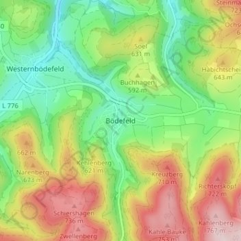
Name: Bödefeld topographic map, elevation, terrain.
Average elevation: 574 m
Minimum elevation: 421 m
Maximum elevation: 786 m
Make a donation
Gear up for your next adventure:
As an Amazon Associate, this site earns from qualifying purchases at no extra cost to you.