Geolocate

Antalya topographic map

Click on the map to display elevation.

Antalya

While the city itself only has modest elevation changes, Antalya has high mountains in all directions to its interior. With moisture being trapped, the local climate thus has high winter rainfall, while the interior bay setting result in very hot summers for a coastal city.

Wikipedia (CC-BY-SA 3.0)

About this map

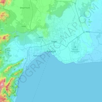
Name: Antalya topographic map, elevation, terrain.

Location: Antalya, Muratpaşa, Antalya, Mediterranean Region, 07050, Turkey (36.72657 30.54302 37.04657 30.86302)

Average elevation: 117 m

Minimum elevation: 0 m

Maximum elevation: 1,614 m

Other topographic maps

Click on a map to view its topography, its elevation and its terrain.

Muratpaşa

Turkey > Muratpaşa

Average elevation: 53 m

Gear up for your next adventure:

Lightweight Backpacking Tent - Compact tent for efficient hiking trips
🧶550 Survival Paracord - Versatile utility cord for emergency repairs and rigging
🧢Outdoor Visor - Breathable visor for sunny hikes
🧥Softshell Hiking Jacket - The perfect balance of wind protection and breathability
🥾Hiking Shorts - Breathable shorts suitable for summer hikes

As an Amazon Associate, this site earns from qualifying purchases at no extra cost to you.