
Make a donation
Gear up for your next adventure:
As an Amazon Associate, this site earns from qualifying purchases at no extra cost to you.
Nowy Sącz topographic map
Click on the map to display elevation.
Make a donation
Gear up for your next adventure:
As an Amazon Associate, this site earns from qualifying purchases at no extra cost to you.
Nowy Sącz
Nowy Sącz is located at the confluence of the Kamienica River and Dunajec, about 20 kilometres (12 miles) north of the Slovak border, in the Sądecka Valley (Kotlina Sądecka) at an altitude of 381 metres (1,250 feet). It is surrounded by ranges of the eastern Outer Western Carpathian Mountains: Beskid Sądecki to the south, Beskid Wyspowy to the west, Beskid Niski to the southeast, and the foothills of Pogórze Rożnowskie to the north. The geological basis is Carpathian flysch – an undifferentiated grey-banded sandstone – with alluvial sediment from the Dunajec, Poprad, and Kamienica rivers in the valley basin.
Make a donation
Gear up for your next adventure:
As an Amazon Associate, this site earns from qualifying purchases at no extra cost to you.
About this map
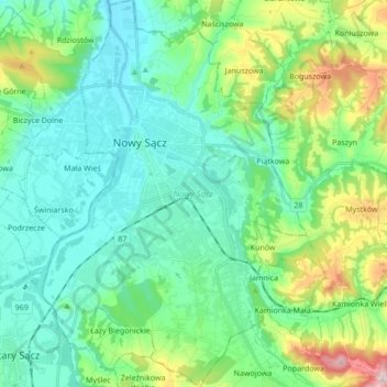
Name: Nowy Sącz topographic map, elevation, terrain.
Location: Nowy Sącz, gmina Chełmiec, Lesser Poland Voivodeship, Poland (49.55494 20.64841 49.66556 20.76487)
Average elevation: 364 m
Minimum elevation: 268 m
Maximum elevation: 681 m
Make a donation
Gear up for your next adventure:
As an Amazon Associate, this site earns from qualifying purchases at no extra cost to you.