
Make a donation
Gear up for your next adventure:
As an Amazon Associate, this site earns from qualifying purchases at no extra cost to you.
Náchod topographic map
Click on the map to display elevation.
Make a donation
Gear up for your next adventure:
As an Amazon Associate, this site earns from qualifying purchases at no extra cost to you.
Náchod
Náchod is located about 31 kilometres (19 mi) northeast of Hradec Králové, on the border with Poland. It lies in the northern tip of the Podorlická Uplands. The highest point of the municipal territory is the hill Malinová hora with an altitude of 637 metres (2,090 ft). The town is situated in the valley of the river Metuje. There are two ponds in the northwestern part of the territory, Podborný and Odkaliště.
Make a donation
Gear up for your next adventure:
As an Amazon Associate, this site earns from qualifying purchases at no extra cost to you.
About this map
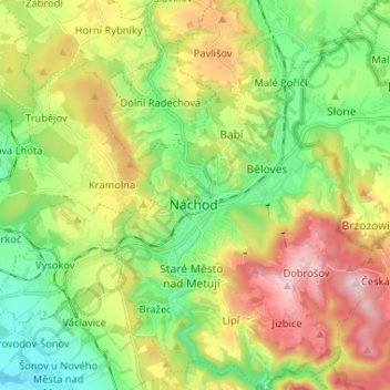
Name: Náchod topographic map, elevation, terrain.
Location: Náchod, okres Náchod, Královéhradecký kraj, Northeast, Czechia (50.37720 16.13578 50.46009 16.22185)
Average elevation: 420 m
Minimum elevation: 280 m
Maximum elevation: 635 m
Make a donation
Gear up for your next adventure:
As an Amazon Associate, this site earns from qualifying purchases at no extra cost to you.