Geolocate

Bentong topographic map

Click on the map to display elevation.

About this map

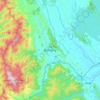
Name: Bentong topographic map, elevation, terrain.

Location: Bentong, Pahang, 29700, Malaysia (3.35964 101.75335 3.67964 102.07335)

Average elevation: 407 m

Minimum elevation: 46 m

Maximum elevation: 1,760 m

Other topographic maps

Click on a map to view its topography, its elevation and its terrain.

Chini Lake

Malaysia > Pahang > Kampung Tanjung Puput

Average elevation: 42 m

Chereh Reservoir

Malaysia > Pahang

Average elevation: 109 m

Gear up for your next adventure:

❄️Traction Ice Cleats - Slip-on spikes for icy trails and winter hiking
🏕️Camping Hammock - Integrated protection for sleeping between trees
🧴First Aid Kit - Essential first aid supplies for outdoor emergencies
🏃Hydration Running Vest - Carry water and maps close to your body for speed
🌡️Emergency Mylar Blankets - Compact thermal protection for unexpected nights outdoors

As an Amazon Associate, this site earns from qualifying purchases at no extra cost to you.