Geolocate

Pataias topographic map

Click on the map to display elevation.

About this map

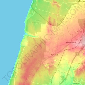
Name: Pataias topographic map, elevation, terrain.

Location: Pataias, Alcobaça, Leiria, Portugal (39.63515 -9.07295 39.74154 -8.90967)

Average elevation: 72 m

Minimum elevation: 0 m

Maximum elevation: 172 m

Other topographic maps

Click on a map to view its topography, its elevation and its terrain.

Vimeiro

Portugal > Leiria > Alcobaça

Average elevation: 122 m

Montes

Portugal > Leiria > Alcobaça

Average elevation: 82 m

Pinhal Fanheiro

Portugal > Leiria > Alcobaça > Bárrio

Average elevation: 124 m

Ribafria

Portugal > Leiria > Alcobaça > Benedita

Average elevation: 173 m

Quinta da Ferraria

Portugal > Leiria > Alcobaça

Average elevation: 72 m

Cumeira

Portugal > Leiria > Alcobaça

Average elevation: 126 m

Pataias

Portugal > Leiria > Alcobaça

Average elevation: 104 m

Gear up for your next adventure:

🔨Vehicle Emergency Tool - Safety tool for remote road trips to trailheads
🔭Compact Binoculars - Lightweight optics for scouting trails and wildlife
🥾Mountain Trail Shoes - High-traction shoes for mountain trails
👟Sport Hiking Sandals - Breathable footwear for water crossings and camp rest
🧦Thermal Socks - Warm socks for winter hiking or camping

As an Amazon Associate, this site earns from qualifying purchases at no extra cost to you.