Geolocate

Invorio topographic map

Click on the map to display elevation.

About this map

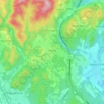
Name: Invorio topographic map, elevation, terrain.

Location: Invorio, Novara, Piedmont, 28045, Italy (45.72531 8.45018 45.78687 8.51288)

Average elevation: 405 m

Minimum elevation: 279 m

Maximum elevation: 698 m

Other topographic maps

Click on a map to view its topography, its elevation and its terrain.

Agrate

Italy > Piedmont > Novara

Average elevation: 324 m

Pisogno

Italy > Piedmont > Novara > Miasino

Average elevation: 527 m

Gaggiolo

Italy > Piedmont > Novara

Average elevation: 211 m

Gear up for your next adventure:

🌬️Windproof Camp Stove - Efficient cooking even on exposed mountain peaks
🔦LED Flashlight - Powerful and long-lasting flashlight for camping and emergencies
📷Outdoor Action Camera - Capture high-elevation views and rugged adventures
🧤Insulated Winter Gloves - Heavy-duty protection for sub-zero Canadian adventures
🧤Rechargeable Heated Gloves - Extreme warmth for Canadian winter expeditions

As an Amazon Associate, this site earns from qualifying purchases at no extra cost to you.