Fulda topographic map
Click on the map to display elevation.
About this map
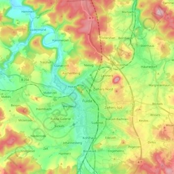
Name: Fulda topographic map, elevation, terrain.
Location: Fulda, Landkreis Fulda, Hesse, Germany (50.49954 9.56614 50.62941 9.73298)
Average elevation: 324 m
Minimum elevation: 225 m
Maximum elevation: 470 m
Other topographic maps
Click on a map to view its topography, its elevation and its terrain.
Milseburg
Germany > Hesse > Landkreis Fulda
The Milseburg is an extinct volcano and at 835 metres (2,740 ft) above sea level the second highest elevation in the Hessian part of the Rhön Mountains, Germany. The hill is located east of Fulda, near the villages of Kleinsassen and Danzwiesen. It is a popular destination for hikers and bikers.…
Average elevation: 619 m