Geolocate
👉 Easily get elevation data in JSON, GeoTIFF and KML formats using Elevation API
Thank you for supporting this site ❤️
Make a donation

Hayfork topographic map

Click on the map to display elevation.

Hayfork

Hayfork is located at 40°34′17″N 123°8′48″W / 40.57139°N 123.14667°W / 40.57139; -123.14667 (40.571406, -123.146619) at an elevation of 2310 feet.

Wikipedia (CC-BY-SA 3.0)

About this map

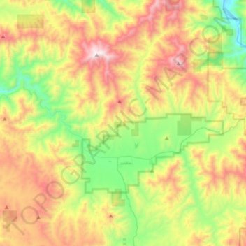
Name: Hayfork topographic map, elevation, terrain.

Location: Hayfork, Trinity County, California, 96041, United States (40.48614 -123.26953 40.63201 -122.99754)

Average elevation: 1,030 m

Minimum elevation: 531 m

Maximum elevation: 1,898 m

Gear up for your next adventure:

🥫Freeze-Dried Meals - Lightweight, high-calorie nutrition for multi-day treks
🚲Heavy Duty Bike Lock - Secure your bike at the trailhead or during stops
🌬️Windproof Camp Stove - Efficient cooking even on exposed mountain peaks
👟Trail Running Shoes - Agile footwear for fast-paced topographic exploration
🧦Crew Hiking Socks - Comfortable socks for long-distance hikes

As an Amazon Associate, this site earns from qualifying purchases at no extra cost to you.