
Make a donation
Gear up for your next adventure:
As an Amazon Associate, this site earns from qualifying purchases at no extra cost to you.
Peneda-Gerês National Park topographic map
Click on the map to display elevation.
Make a donation
Gear up for your next adventure:
As an Amazon Associate, this site earns from qualifying purchases at no extra cost to you.
Peneda-Gerês National Park
During the Pleistocene (approximately 1.8 to 0.001 Ma ago) climatic variations resulted in an extension of glacial fields to the mid-latitudes. While there are no remnants of glaciers now, their Ice Age products (U-shaped valleys, moraines, glacial deposits, polished and natural granite surfaces) are identified in the Serra da Peneda, Serra do Soajo and Serra do Gerês mountain ranges. The principal watersheds that cross the park are those of the Minho (occupying 2% of the park), Lima (47.8%) and Cávado (50.2%), with brooks and waterfalls common on many of the mountain slopes, in addition to several secondary tributaries (such as the Homem, Rabagão, Castro Laboreiro, and Arado rivers). The Lima cuts across the PNPG east to west, while the Cávado serves the southern limits of the districts of Vila Real and Braga. Fractures in the landscape have confined the rivers to deep, straight valleys and are visible in the younger granite outcrops visible in the uncovered higher altitudes. Owing to the number tributaries, the construction of hydroelectrical dams has been undertaken to generate electricity across six locations: Alto Rabagão, Paradela, Caniçada, Vilarinho da Furna, Touvedo and Lindoso.
Make a donation
Gear up for your next adventure:
As an Amazon Associate, this site earns from qualifying purchases at no extra cost to you.
About this map
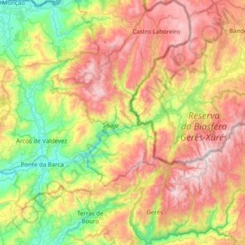
Name: Peneda-Gerês National Park topographic map, elevation, terrain.
Location: Peneda-Gerês National Park, Viana do Castelo, Portugal (41.67220 -8.39861 42.08278 -7.87304)
Average elevation: 629 m
Minimum elevation: 2 m
Maximum elevation: 1,523 m
Make a donation
Gear up for your next adventure:
As an Amazon Associate, this site earns from qualifying purchases at no extra cost to you.
Other topographic maps
Click on a map to view its topography, its elevation and its terrain.
Make a donation
Gear up for your next adventure:
As an Amazon Associate, this site earns from qualifying purchases at no extra cost to you.