
Pirassununga topographic map
Click on the map to display elevation.
Pirassununga
Pirassununga is a municipality in the state of São Paulo in Brazil, with an altitude of 627 meters. The population is 76,877 (2020 est.) in an area of 727 km2.
About this map
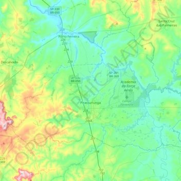
Name: Pirassununga topographic map, elevation, terrain.
Average elevation: 650 m
Minimum elevation: 532 m
Maximum elevation: 1,039 m
Other topographic maps
Click on a map to view its topography, its elevation and its terrain.
Kobayat Líbano
Brazil > São Paulo > Região Metropolitana de Piracicaba > Piracicaba
Average elevation: 521 m
Nova Piracicaba
Brazil > São Paulo > Região Metropolitana de Piracicaba > Piracicaba
Average elevation: 493 m
Mirante Rio Piracicaba
Brazil > São Paulo > Região Metropolitana de Piracicaba > Piracicaba
Average elevation: 505 m