Geolocate

Lamas topographic map

Click on the map to display elevation.

About this map

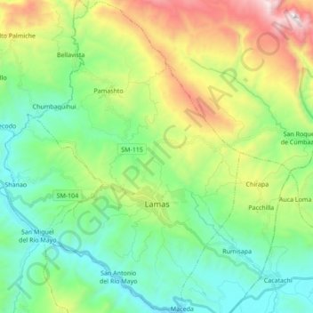
Name: Lamas topographic map, elevation, terrain.

Location: Lamas, Province of Lamas, San Martín, Peru (-6.48153 -76.58392 -6.31103 -76.47097)

Average elevation: 702 m

Minimum elevation: 229 m

Maximum elevation: 1,781 m

Gear up for your next adventure:

🛌Down Sleeping Bag - Superior warmth-to-weight ratio for cold nights
🥾Trekking Boots - Durable boots for long-distance trekking
🗺️Topographic Maps - Detailed maps to explore trails, mountains, and wilderness areas
💡Solar Camping Lamp - Eco-friendly lighting for campsites
🩹Compact First Aid Kit - Pre-packed essentials for common trail injuries

As an Amazon Associate, this site earns from qualifying purchases at no extra cost to you.