
Thyez topographic map
Click on the map to display elevation.
About this map
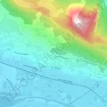
Name: Thyez topographic map, elevation, terrain.
Average elevation: 663 m
Minimum elevation: 457 m
Maximum elevation: 1,323 m
Other topographic maps
Click on a map to view its topography, its elevation and its terrain.
Mont Maudit / Monte Maudit
France > Auvergne-Rhône-Alpes > Upper Savoy > Chamonix-Mont-Blanc
Average elevation: 3,871 m
Les Frasserands
France > Auvergne-Rhône-Alpes > Upper Savoy > Chamonix-Mont-Blanc > Les Frasserands
Average elevation: 1,704 m