

Beaverton topographic map
Click on the map to display elevation.
Beaverton
Beaverton covers a total area of 19.7 square miles (51 km2), all of it land except for small creeks, ponds, and lakes. The city is located along the eastern edge of the Tualatin Valley just west of the Tualatin Mountains. It is bordered by Portland to the east, Hillsboro to the west, and Tigard to the south. Much of the remaining area surrounding Beaverton in the north and southwest constitutes unincorporated Washington County land. The elevation within city limits ranges from as high as 698.2 feet (212.8 m) above sea level to as low as 131.7 feet (40.1 m) above sea level. The city averages at 189 feet (58 m) above sea level.
About this map
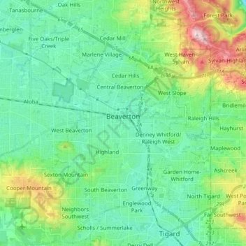
Name: Beaverton topographic map, elevation, terrain.
Location: Beaverton, Washington County, Oregon, United States (45.42459 -122.87772 45.54296 -122.74366)
Average elevation: 106 m
Minimum elevation: 15 m
Maximum elevation: 386 m
Other topographic maps
Click on a map to view its topography, its elevation and its terrain.

Vern Galaway Memorial Park
United States > Oregon > Washington County > North Plains
Average elevation: 56 m