
Make a donation
Gear up for your next adventure:
As an Amazon Associate, this site earns from qualifying purchases at no extra cost to you.
Villarrica topographic map
Click on the map to display elevation.
Make a donation
Gear up for your next adventure:
As an Amazon Associate, this site earns from qualifying purchases at no extra cost to you.
Villarrica
Other lakes found nearby include Calafquén, Caburgua, Huilipilún and Colico. In the summer water sports and sunbathing are popular activities in the warm temperatures experienced at the low altitudes ranging from 200 to 500m above sea level.
Make a donation
Gear up for your next adventure:
As an Amazon Associate, this site earns from qualifying purchases at no extra cost to you.
About this map
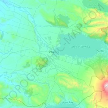
Name: Villarrica topographic map, elevation, terrain.
Location: Villarrica, Provincia de Cautín, Araucania Region, Chile (-39.51396 -72.43682 -39.05961 -71.90895)
Average elevation: 421 m
Minimum elevation: 116 m
Maximum elevation: 2,831 m
Make a donation
Gear up for your next adventure:
As an Amazon Associate, this site earns from qualifying purchases at no extra cost to you.
Other topographic maps
Click on a map to view its topography, its elevation and its terrain.
Make a donation
Gear up for your next adventure:
As an Amazon Associate, this site earns from qualifying purchases at no extra cost to you.
Volcán Llaima
Chile > Araucanía Region > Provincia de Cautín > Vilcún
The average elevation of the terrain around Llaima is about 740 m asl.
Average elevation: 2,519 m
Make a donation
Gear up for your next adventure:
As an Amazon Associate, this site earns from qualifying purchases at no extra cost to you.