
Make a donation
Gear up for your next adventure:
As an Amazon Associate, this site earns from qualifying purchases at no extra cost to you.
Bad Sachsa topographic map
Click on the map to display elevation.
Make a donation
Gear up for your next adventure:
As an Amazon Associate, this site earns from qualifying purchases at no extra cost to you.
About this map
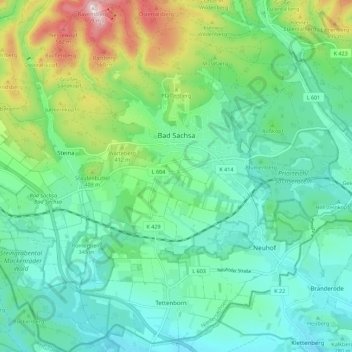
Name: Bad Sachsa topographic map, elevation, terrain.
Location: Bad Sachsa, Landkreis Göttingen, Lower Saxony, 37441, Germany (51.55369 10.49724 51.62295 10.59264)
Average elevation: 341 m
Minimum elevation: 234 m
Maximum elevation: 652 m
Make a donation
Gear up for your next adventure:
As an Amazon Associate, this site earns from qualifying purchases at no extra cost to you.
Other topographic maps
Click on a map to view its topography, its elevation and its terrain.
Kamschlacken
Germany > Lower Saxony > Landkreis Göttingen > Osterode am Harz > Riefensbeek-Kamschlacken
Average elevation: 513 m
Zoll
Germany > Lower Saxony > Landkreis Göttingen > Bad Lauterberg im Harz > Barbis
Average elevation: 315 m
Make a donation
Gear up for your next adventure:
As an Amazon Associate, this site earns from qualifying purchases at no extra cost to you.
Make a donation
Gear up for your next adventure:
As an Amazon Associate, this site earns from qualifying purchases at no extra cost to you.