
Cenicientos topographic map
Click on the map to display elevation.
About this map
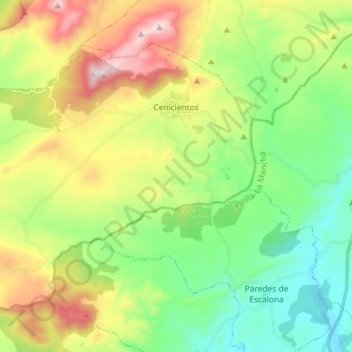
Name: Cenicientos topographic map, elevation, terrain.
Location: Cenicientos, Community of Madrid, 28650, Spain (40.19956 -4.57901 40.28334 -4.43438)
Average elevation: 715 m
Minimum elevation: 430 m
Maximum elevation: 1,223 m
Other topographic maps
Click on a map to view its topography, its elevation and its terrain.
Madrid
Spain > Community of Madrid > Área metropolitana de Madrid y Corredor del Henares > Madrid
Average elevation: 650 m