Geolocate

Rehau topographic map

Click on the map to display elevation.

About this map

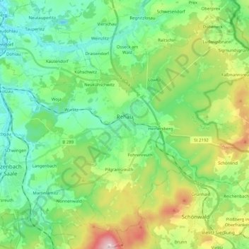
Name: Rehau topographic map, elevation, terrain.

Location: Rehau, Landkreis Hof, Bavaria, 95111, Germany (50.19006 11.96022 50.30169 12.16202)

Average elevation: 575 m

Minimum elevation: 472 m

Maximum elevation: 825 m

Gear up for your next adventure:

🥾Durable Hiking Shoes - Long-lasting shoes for frequent hiking
🔋Emergency Crank Radio - Weather alerts and power without needing batteries
🥾Hiking Boots - Sturdy boots providing ankle support and traction on rugged trails
🧢Sun Protection Cap - Breathable cap to protect from sun exposure
🛶Waterproof Dry Bags - Keep electronics and clothes dry during river crossings

As an Amazon Associate, this site earns from qualifying purchases at no extra cost to you.