Geolocate

Orto topographic map

Click on the map to display elevation.

About this map
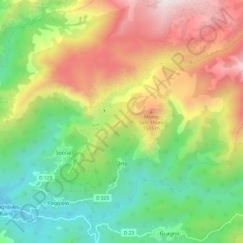
Name: Orto topographic map, elevation, terrain.

Location: Orto, Ajaccio, South Corsica, Corsica, Metropolitan France, 20125, France (42.17138 8.91858 42.22429 9.00604)

Average elevation: 1,056 m

Minimum elevation: 419 m

Maximum elevation: 1,981 m

Other topographic maps

Click on a map to view its topography, its elevation and its terrain.
Col de la Croix

France > Corsica > South Corsica > Osani

Average elevation: 182 m

Levie

France > Corsica > South Corsica > Levie > Levie

Average elevation: 630 m

Alzo Di Lano

France > Corsica > South Corsica > Zonza

Average elevation: 478 m

Vetriccia

France > Corsica > South Corsica > Partinello

Average elevation: 167 m

Gear up for your next adventure:

👟Leg Gaiters - Keep debris, mud, and snow out of your boots
🏃Hydration Running Vest - Carry water and maps close to your body for speed
🧦Hiking Liner Socks - Thin base layer to prevent friction and blisters
🔦LED Flashlight - Powerful and long-lasting flashlight for camping and emergencies
🧥Thermal Fleece Jacket - Versatile insulation for changing mountain temperatures

As an Amazon Associate, this site earns from qualifying purchases at no extra cost to you.