
Quilchena topographic map
Click on the map to display elevation.
About this map
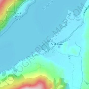
Name: Quilchena topographic map, elevation, terrain.
Average elevation: 677 m
Minimum elevation: 624 m
Maximum elevation: 1,030 m
Thompson-Nicola Regional District trails, hiking, mountain biking, running and outdoor activities
Other topographic maps
Click on a map to view its topography, its elevation and its terrain.
Brenda Lake
Canada > British Columbia > Thompson-Nicola Regional District > Area M (Beautiful Nicola Valley - North)
Average elevation: 1,753 m
Wasley Lake
Canada > British Columbia > Thompson-Nicola Regional District > Area M (Beautiful Nicola Valley - North)
Average elevation: 1,291 m
Dardanelles Lake
Canada > British Columbia > Thompson-Nicola Regional District > Area M (Beautiful Nicola Valley - North)
Average elevation: 1,269 m
Drum Lake
Canada > British Columbia > Thompson-Nicola Regional District > Area M (Beautiful Nicola Valley - North)
Average elevation: 1,166 m
Hatheume Lake
Canada > British Columbia > Thompson-Nicola Regional District > Area M (Beautiful Nicola Valley - North)
Average elevation: 1,423 m
Pennask Lake
Canada > British Columbia > Thompson-Nicola Regional District > Area M (Beautiful Nicola Valley - North)
Average elevation: 1,430 m
Mamit Lake
Canada > British Columbia > Thompson-Nicola Regional District > Area M (Beautiful Nicola Valley - North)
Average elevation: 1,122 m
Glimpse Lake
Canada > British Columbia > Thompson-Nicola Regional District > Area M (Beautiful Nicola Valley - North)
Average elevation: 1,211 m