
Make a donation
Gear up for your next adventure:
As an Amazon Associate, this site earns from qualifying purchases at no extra cost to you.
Huayna Potosí topographic map
Click on the map to display elevation.
Make a donation
Gear up for your next adventure:
As an Amazon Associate, this site earns from qualifying purchases at no extra cost to you.
Huayna Potosí
Huayna Potosí is a fold mountain located in western Bolivia, near the city of El Alto and approximately 25 km (16 mi) north of La Paz, the country's administrative capital. It rises to an elevation of 6,088 m (19,974 ft) above sea level and forms part of the Cordillera Real range of the larger Andes, which runs parallel between the intermountain plains of the Altiplano and the lowland forests of the Yungas region leading to the Amazon basin.
Make a donation
Gear up for your next adventure:
As an Amazon Associate, this site earns from qualifying purchases at no extra cost to you.
About this map
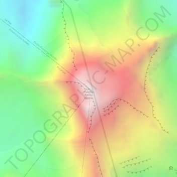
Name: Huayna Potosí topographic map, elevation, terrain.
Average elevation: 5,374 m
Minimum elevation: 4,733 m
Maximum elevation: 6,065 m
Make a donation
Gear up for your next adventure:
As an Amazon Associate, this site earns from qualifying purchases at no extra cost to you.