
Thank you for supporting this site ❤️
Make a donation
Make a donation
Gear up for your next adventure:
As an Amazon Associate, this site earns from qualifying purchases at no extra cost to you.
Saalbach topographic map
Click on the map to display elevation.
Thank you for supporting this site ❤️
Make a donation
Make a donation
Gear up for your next adventure:
As an Amazon Associate, this site earns from qualifying purchases at no extra cost to you.
About this map
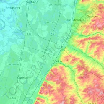
Name: Saalbach topographic map, elevation, terrain.
Location: Saalbach, Landkreis Karlsruhe, Baden-Württemberg, Germany (49.03427 8.47055 49.25218 8.70012)
Average elevation: 142 m
Minimum elevation: 93 m
Maximum elevation: 273 m
Thank you for supporting this site ❤️
Make a donation
Make a donation
Gear up for your next adventure:
As an Amazon Associate, this site earns from qualifying purchases at no extra cost to you.
Other topographic maps
Click on a map to view its topography, its elevation and its terrain.
Dettenheim (Baden)
Germany > Baden-Württemberg > Landkreis Karlsruhe > Dettenheim
Average elevation: 100 m