
Thank you for supporting this site ❤️
Make a donation
Make a donation
Gear up for your next adventure:
As an Amazon Associate, this site earns from qualifying purchases at no extra cost to you.
Bridgwater topographic map
Click on the map to display elevation.
Thank you for supporting this site ❤️
Make a donation
Make a donation
Gear up for your next adventure:
As an Amazon Associate, this site earns from qualifying purchases at no extra cost to you.
About this map
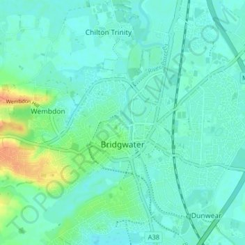
Name: Bridgwater topographic map, elevation, terrain.
Location: Bridgwater, Somerset, England, United Kingdom (51.11317 -3.03567 51.15061 -2.97052)
Average elevation: 10 m
Minimum elevation: 2 m
Maximum elevation: 36 m
Thank you for supporting this site ❤️
Make a donation
Make a donation
Gear up for your next adventure:
As an Amazon Associate, this site earns from qualifying purchases at no extra cost to you.
Other topographic maps
Click on a map to view its topography, its elevation and its terrain.
Thorne St Margaret
United Kingdom > England > Somerset > Somerset West and Taunton > Holywell Lake
Average elevation: 94 m