Geolocate

Paravoor topographic map

Click on the map to display elevation.

About this map

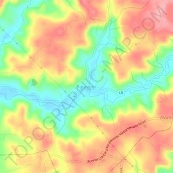
Name: Paravoor topographic map, elevation, terrain.

Location: Paravoor, Payyannur Taluk, Kannur, Kerala, 670306, India (12.10643 75.31732 12.14643 75.35732)

Average elevation: 73 m

Minimum elevation: 10 m

Maximum elevation: 128 m

Other topographic maps

Click on a map to view its topography, its elevation and its terrain.

Payyannur Taluk

India > Kerala > Payyannur Taluk

Average elevation: 62 m

Kalliasseri Block

India > Kerala > Payyannur Taluk

Average elevation: 14 m

Gear up for your next adventure:

🔨Vehicle Emergency Tool - Safety tool for remote road trips to trailheads
🧰Multitool Knife - Compact and versatile tool for outdoor use
🧭Orienteering Kit - Tools for map reading and navigation in the wild
🥾Hiking Shoes - Durable and comfortable shoes for trail hiking
🧭GPS Handheld Device - Reliable GPS navigation for outdoor adventures

As an Amazon Associate, this site earns from qualifying purchases at no extra cost to you.