Geolocate

Luoyang topographic map

Click on the map to display elevation.

About this map

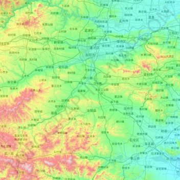
Name: Luoyang topographic map, elevation, terrain.

Location: Luoyang, Henan, China (33.56382 111.12981 35.07148 112.97405)

Average elevation: 464 m

Minimum elevation: 80 m

Maximum elevation: 2,104 m

Other topographic maps

Click on a map to view its topography, its elevation and its terrain.

Kaifeng

China > Henan > Gulou District > Xiangguosi Subdistrict

Average elevation: 75 m

Xinyang

China > Henan > Qianjin Subdistrict

Average elevation: 105 m

Daxingnanjiecun

China > Henan > Tangyin County

Average elevation: 85 m

Changtai

China > Henan

Average elevation: 84 m

Gear up for your next adventure:

🧣Evaporative Cooling Towel - Beat the heat during intense summer climbs
🥘Camping Cookware Set - Compact nesting pots and pans for trail cooking
🥾Mountain Hiking Shoes - Shoes with superior grip for mountainous terrain
🚑Survival Whistle - Signal for help across long distances in mountains
🥾Durable Hiking Shoes - Long-lasting shoes for frequent hiking

As an Amazon Associate, this site earns from qualifying purchases at no extra cost to you.