Geolocate

Hailer topographic map

Click on the map to display elevation.

About this map
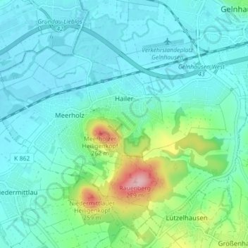
Name: Hailer topographic map, elevation, terrain.

Location: Hailer, Gelnhausen, Main-Kinzig-Kreis, Hesse, Germany (50.16284 9.12172 50.20109 9.19178)

Average elevation: 156 m

Minimum elevation: 122 m

Maximum elevation: 294 m

Other topographic maps

Click on a map to view its topography, its elevation and its terrain.

Hanau

Germany > Hesse > Main-Kinzig-Kreis > Hanau

Average elevation: 110 m

Ramholz

Germany > Hesse > Main-Kinzig-Kreis > Vollmerz

Average elevation: 373 m

Gear up for your next adventure:

🧢Sun Hat - Wide-brim hat for sun protection
💧Hydration Pack - Hands-free hydration system for long hikes
🛌Insulated Sleeping Pad - Critical thermal barrier between you and the cold ground
🕶️Polarized Sunglasses - Protect your eyes with durable polarized lenses
🛶Kayak Dry Bag - Waterproof storage for kayaking adventures

As an Amazon Associate, this site earns from qualifying purchases at no extra cost to you.