
Make a donation
Gear up for your next adventure:
As an Amazon Associate, this site earns from qualifying purchases at no extra cost to you.
Auburn Hills topographic map
Click on the map to display elevation.
Make a donation
Gear up for your next adventure:
As an Amazon Associate, this site earns from qualifying purchases at no extra cost to you.
About this map
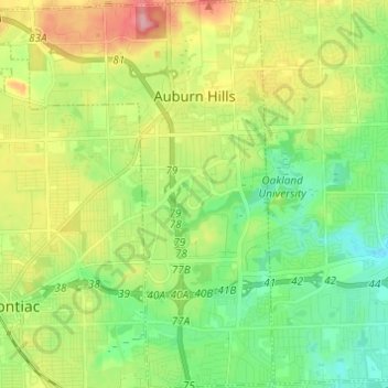
Name: Auburn Hills topographic map, elevation, terrain.
Location: Auburn Hills, Oakland County, Michigan, 48326, United States (42.61994 -83.32895 42.70953 -83.20922)
Average elevation: 284 m
Minimum elevation: 236 m
Maximum elevation: 366 m
Make a donation
Gear up for your next adventure:
As an Amazon Associate, this site earns from qualifying purchases at no extra cost to you.
Other topographic maps
Click on a map to view its topography, its elevation and its terrain.
Oakley Park
United States > Michigan > Oakland County > Commerce Charter Township
Average elevation: 282 m
Make a donation
Gear up for your next adventure:
As an Amazon Associate, this site earns from qualifying purchases at no extra cost to you.