Geolocate

Itatiaia topographic map

Click on the map to display elevation.

Itatiaia

Itatiaia (Portuguese pronunciation: [itɐtʃiˈaj.jɐ]) is a Brazilian municipality of the state of Rio de Janeiro. It is located at an altitude of 695 m (2,280 ft). Its population was 32,064 in 2020 and its area is 224.96 km2 (86.86 sq mi).

Wikipedia (CC-BY-SA 3.0)

About this map

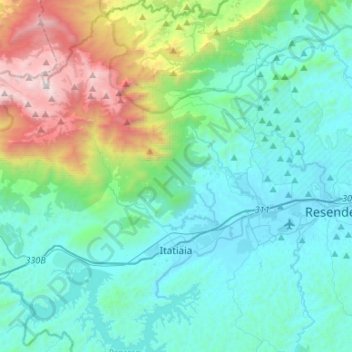
Name: Itatiaia topographic map, elevation, terrain.

Location: Itatiaia, Região Geográfica Imediata de Resende, Região Geográfica Intermediária de Volta Redonda-Barra Mansa, Rio de Janeiro, Southeast Region, Brazil (-22.56605 -44.66289 -22.32025 -44.47851)

Average elevation: 868 m

Minimum elevation: 391 m

Maximum elevation: 2,762 m

Other topographic maps

Click on a map to view its topography, its elevation and its terrain.

Penedo

Brazil > Rio de Janeiro > Itatiaia

Average elevation: 461 m

Gear up for your next adventure:

🧤Insulated Winter Gloves - Heavy-duty protection for sub-zero Canadian adventures
🧦Hiking Liner Socks - Thin base layer to prevent friction and blisters
🧥Softshell Hiking Jacket - The perfect balance of wind protection and breathability
🛌Insulated Sleeping Pad - Critical thermal barrier between you and the cold ground
🥾Hiking Shoes - Durable and comfortable shoes for trail hiking

As an Amazon Associate, this site earns from qualifying purchases at no extra cost to you.