
Oneida County topographic map
Click on the map to display elevation.
Oneida County
Oxford Peak is the highest point in the county at 9,285 ft (2830.2 m) above sea level. Alternating valleys and ridges of mountains or hills typify the topography, with grassland and sagebrush covering most areas. The Curlew National Grassland lies within the county.
About this map
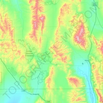
Name: Oneida County topographic map, elevation, terrain.
Location: Oneida County, Idaho, United States (41.99724 -113.00008 42.50306 -112.07027)
Average elevation: 1,678 m
Minimum elevation: 1,325 m
Maximum elevation: 2,747 m