Geolocate

Purulia topographic map

Click on the map to display elevation.

Purulia

Purulia is located at 23°20′N 86°22′E / 23.33°N 86.37°E / 23.33; 86.37. It has an average elevation of 228 metres (748 feet).

Wikipedia (CC-BY-SA 3.0)

About this map

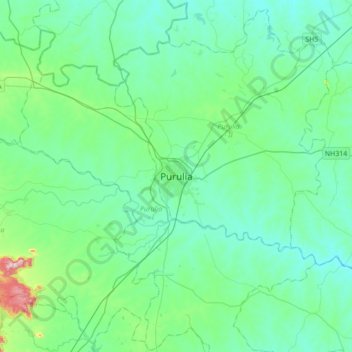
Name: Purulia topographic map, elevation, terrain.

Location: Purulia, Purulia - II, Puruliya, West Bengal, 723101, India (23.16919 86.20724 23.48919 86.52724)

Average elevation: 241 m

Minimum elevation: 178 m

Maximum elevation: 583 m

Gear up for your next adventure:

Lightweight Camping Tent - Portable shelter optimized for Canadian backcountry camping
🔭Compact Binoculars - Lightweight optics for scouting trails and wildlife
🧦Merino Wool Socks - Moisture-wicking comfort for long-distance hiking
🛶Kayak Accessories - Essential gear for safe and fun kayaking adventures
🧭GPS Handheld Device - Reliable GPS navigation for outdoor adventures

As an Amazon Associate, this site earns from qualifying purchases at no extra cost to you.