Geolocate

Sakurajima topographic map

Click on the map to display elevation.

About this map

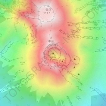
Name: Sakurajima topographic map, elevation, terrain.

Location: Sakurajima, Kagoshima, Kagoshima Prefecture, 892-8677, Japan (31.58052 130.65793 31.58062 130.65803)

Average elevation: 666 m

Minimum elevation: 258 m

Maximum elevation: 1,096 m

Other topographic maps

Click on a map to view its topography, its elevation and its terrain.

Hoshigamine

Japan > Kagoshima

Average elevation: 89 m

Gear up for your next adventure:

🗺️Topographic Maps - Detailed maps to explore trails, mountains, and wilderness areas
🛰️Satellite Messenger - Emergency communication for areas with no cell service
🧦Crew Hiking Socks - Comfortable socks for long-distance hikes
🥾Waterproof Hiking Shoes - Durable shoes for wet and rugged trails
🥾Waterproof Hiking Boots - Essential footwear for rugged terrain and wet Canadian trails

As an Amazon Associate, this site earns from qualifying purchases at no extra cost to you.