Geolocate

Rambouillet topographic map

Click on the map to display elevation.

About this map
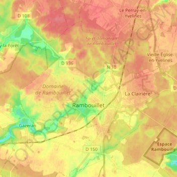
Name: Rambouillet topographic map, elevation, terrain.

Location: Rambouillet, Yvelines, Ile-de-France, Metropolitan France, 78120, France (48.61917 1.76539 48.68840 1.90247)

Average elevation: 166 m

Minimum elevation: 130 m

Maximum elevation: 186 m

Other topographic maps

Click on a map to view its topography, its elevation and its terrain.

Rodon

France > Ile-de-France > Yvelines

Average elevation: 167 m

Hautvilliers

France > Ile-de-France > Yvelines > Chevreuse

Average elevation: 127 m

La Corse

France > Ile-de-France > Yvelines > Élancourt

Average elevation: 165 m

Gear up for your next adventure:

🥾Waterproof Hiking Boots - Essential footwear for rugged terrain and wet Canadian trails
🧥Waterproof Jacket - Lightweight rain jackets for hiking and outdoor activities
🦯Trekking Poles - Reduced impact on joints for steep topographic climbs
🥾Lightweight Hiking Boots - Boots for comfort and mobility on long hikes
🧥Fleece Jacket - Warm and lightweight jacket for layering

As an Amazon Associate, this site earns from qualifying purchases at no extra cost to you.