
Make a donation
Gear up for your next adventure:
As an Amazon Associate, this site earns from qualifying purchases at no extra cost to you.
Ghardaia topographic map
Click on the map to display elevation.
Make a donation
Gear up for your next adventure:
As an Amazon Associate, this site earns from qualifying purchases at no extra cost to you.
Ghardaia
Each village was planned in a diverse topography comprising a small island, a ridge, a hilltop, a peak and a recess. The villages were fortified in such a manner that they were inaccessible to the nomadic groups. The five villages set up with identical planning concepts were Ghardaïa, Melika, Beni Isguen, Bou Noura and El Atteuf. The identical “miniature citadels”, as they are termed, each had their own mosque with minaret functioning as watch towers, and the houses built around the mosque in concentric circles and surrounded by a high walls (extending up to the ramparts). The buildings together gave the feel of a fortress to each village. The mosque also provided for storage of grains and arms for defence.
Make a donation
Gear up for your next adventure:
As an Amazon Associate, this site earns from qualifying purchases at no extra cost to you.
About this map
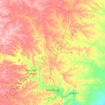
Name: Ghardaia topographic map, elevation, terrain.
Location: Ghardaia, Ghardaia District, Ghardaia, Algeria (32.47352 3.57204 32.70199 3.90997)
Average elevation: 574 m
Minimum elevation: 424 m
Maximum elevation: 702 m
Make a donation
Gear up for your next adventure:
As an Amazon Associate, this site earns from qualifying purchases at no extra cost to you.
Other topographic maps
Click on a map to view its topography, its elevation and its terrain.