
Thank you for supporting this site ❤️
Make a donation
Make a donation
Gear up for your next adventure:
As an Amazon Associate, this site earns from qualifying purchases at no extra cost to you.
Mumbai Metropolitan Region topographic map
Click on the map to display elevation.
Thank you for supporting this site ❤️
Make a donation
Make a donation
Gear up for your next adventure:
As an Amazon Associate, this site earns from qualifying purchases at no extra cost to you.
About this map
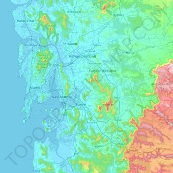
Name: Mumbai Metropolitan Region topographic map, elevation, terrain.
Location: Mumbai Metropolitan Region, Panvel, Raigad, Maharashtra, India (18.63709 72.74417 19.52748 73.46103)
Average elevation: 143 m
Minimum elevation: -3 m
Maximum elevation: 1,201 m
Thank you for supporting this site ❤️
Make a donation
Make a donation
Gear up for your next adventure:
As an Amazon Associate, this site earns from qualifying purchases at no extra cost to you.