Geolocate

Grimma topographic map

Click on the map to display elevation.

About this map

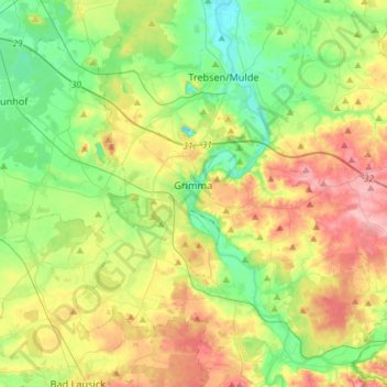
Name: Grimma topographic map, elevation, terrain.

Location: Grimma, Landkreis Leipzig, Saxony, 04668, Germany (51.15649 12.63978 51.31250 12.93169)

Average elevation: 162 m

Minimum elevation: 115 m

Maximum elevation: 236 m

Gear up for your next adventure:

🧼Biodegradable Camp Soap - Environmentally friendly cleaning for gear and body
🧢Outdoor Visor - Breathable visor for sunny hikes
Tent Footprint - Protect tent floor and increase durability
🎒Backpack Rain Cover - External shield to keep your entire pack dry
💡LED Headlamp - Hands-free illumination for night hiking and camping

As an Amazon Associate, this site earns from qualifying purchases at no extra cost to you.