Geolocate

Burgau topographic map

Click on the map to display elevation.

About this map

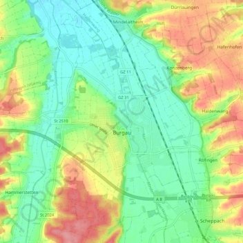
Name: Burgau topographic map, elevation, terrain.

Location: Burgau, Landkreis Günzburg, Bavaria, 89331, Germany (48.40375 10.32828 48.46480 10.43177)

Average elevation: 474 m

Minimum elevation: 438 m

Maximum elevation: 529 m

Other topographic maps

Click on a map to view its topography, its elevation and its terrain.

Oberknöringen

Germany > Bavaria > Landkreis Günzburg > Burgau

Average elevation: 464 m

Gear up for your next adventure:

👟Sport Hiking Sandals - Breathable footwear for water crossings and camp rest
🥾Trekking Boots - Durable boots for long-distance trekking
💡LED Camping Lantern - Illuminate your campsite with long-lasting lanterns
🥾All-Terrain Hiking Boots - Versatile boots for varied hiking conditions
📷Outdoor Action Camera - Capture high-elevation views and rugged adventures

As an Amazon Associate, this site earns from qualifying purchases at no extra cost to you.